Old announcements (most recent at top)
- Because class website was unavailable on th weekend of 2-3 Dec., I have pushed back the deadline for Assignment 2: it is due by 5 pm on Fri 8th Dec (drop-off box is on third floor of Tory building, near Room 3-40). Note: calculation of a temperature gradient is similar to calculation of a height gradient - eg. see slide 4 of Lec 10.
- This seminar on analysis of paleoclimatic data may be of interest (Wed 6 Dec, 3:30 pm).
- Please note there was a typo on the earliest version of Assignment 2... the correct conversion between knots and metres per second is: 1 m s-1 = 1.94 knots.
- Course evaluation will be administered at the start of class, Wed. 29th Nov.
- Kitty Wilkes of Environment Canada will speak about careers with Meteorological Service of Canada (MSC) at 4 pm Monday November 27th, in Tory 3-36. All welcome.
- Final exam Friday 15 December 1400-1600 in Pavilion (Butter Dome) Rows 2, 4, 6
- Please note there was a typo on the earliest version of Assignment 2... the correct conversion between knots and metres per second is: 1 m s-1 = 1.94 knots.
- Quiz 3 (17 Nov/06) and its answers.
- Quiz 3 on Fri 17 Nov. (16 questions, 25 minutes) will cover Chapters 9-12 (inclusive).
- Totalized scores for all work so far (weight: 20 from quizzes, 10 from assignment, 20 from mid-term).
- Mid-term scores
- Mid-term exam Fri 27 Oct. will cover Chapters 1 - 8.
- Some further exclusions to Ch 8 have been added
- Assignment 1 scores and the criteria used in marking.
- Quiz 2 scores (alphabetically by first letter of family name). The second column has been re-scaled by 16/20 to give a score from 16, so as to allow me to choose your best 2 of 3 quizzes. That is, Quiz 2 from 16 = (16/20) * raw score from 20. Thus a 20/20 would become a 16/16, a 15/20 a 12/16, a 10/20 an 8/16, and so on.
- See new link below to trial numeric questions.
- Response to student feedback.
- Assignment 1 due 18 Oct by 5 pm (drop-off box is on third floor of Tory building, near Room 3-40). Here is the data file flanagan.txt associated with the assignment. Note: assignment file updated 2 Oct, adding an extra piece of (given) information.
- Change of plan: Quiz 2 on Friday 13 Oct. will cover to end of Chapter 5 (rather than as earlier announced, to the end of Chapter 6).
- Follow link (Wed 4 Oct) to brief comments made in class regarding the weather maps of Wed 4 Oct.
- Table of data, including equilibrium vapour pressure versus temperature.
- I have added a new slide to lec10.ppt (Lecture 10, Fri 29 Sept) covering how to apply the Geostrophic wind law, using your map and ruler.
- Quiz 1 (22 Sept/06) and its answers.
- Clarification: the "Solar declination", ie. latitudinal position of the sub-solar point, is negative during the N.H. winter. Convention is that when the sun is south of the equatorial plane (ie. between the N.H. fall equinox and the N.H. spring equinox, solar declination is negative).
- Please remember that quizzes vary from year to year due to changes in course content or rate of progress...
- Quiz this Friday 22 Sept. covers Lectures 1-4, ie. material covered up to Friday 15 Sept. Material from Chapter 2 material is NOT included on the quiz.
- Some or all EAS course web sites were inaccessible to instructors and students from sometime late Friday through the weekend. I was unable to upload today's (Monday 18 Sept) powerpoint file until 0910 today (Monday); therefore I will hand out hard copy in class.
- SIGNIFICANT WEATHER DISCUSSION FOR THE CANADIAN PRAIRIES ISSUED BY
THE PRAIRIE AND ARCTIC STORM PREDICTION CENTRE OF ENVIRONMENT CANADA
AT 7:00 AM CDT WEDNESDAY SEPTEMBER 13 2006... DISCUSSION...A COLOSSAL WEATHER PATTERN CHANGE IS UNDERWAY OVER THE PRAIRIES. A DIGGING UPPER TROUGH OVER WESTERN CANADA, AND A STRONG INFLUX OF
ARCTIC AIR AS SEEN ON WV SATELLITE LOOPS, WILL END UP CARVING OUT A
HUGE CLOSED UPPER CENTRE OVER BC/AB BY 15/00Z. ALREADY THE COLD AIR INVADING AT MIDLEVELS IS PROMOTING STRONG UPPER VERTICAL VELOCITIES, AS SEEN WITH SEVERE CONVECTION OVER CENTRAL AB LAST NIGHT
- POST-TROPICAL STORM FLORENCE INTERMEDIATE INFORMATION STATEMENT
ISSUED BY THE CANADIAN HURRICANE CENTRE OF ENVIRONMENT CANADA
AT 12.30 PM NDT WEDNESDAY 13 SEPTEMBER 2006... THE STORM CENTRE WILL COME VERY CLOSE TO
LAND IN SOUTHERN NEWFOUNDLAND... LIKELY THE AVALON PENINSULA. THIS
SHOULD HAVE MINIMAL IMPACT ON THE FORECASTS AND WARNINGS ALREADY IN
EFFECT SINCE THIS IS NO LONGER A HURRICANE... BUT RATHER... A LARGE
SPRAWLING STORM SYSTEM WITH GALE TO STORM FORCE WINDS EXTENDING
OUTWARDS MANY HUNDREDS OF KILOMETRES... NOTEWORTHY REPORTS SO FAR...
OVER MARINE AREAS... PEAK WINDS OF 66 KNOTS AT BUOYS 44141 AND 44139.
...10 METRE SIGNIFICANT WAVE HEIGHTS AT BUOY 44138... OVER LAND AREAS...
...GUSTS TO 133 KM/H AT SAGONA ISLAND.
- At 10:00 Tuesday 12th I added a page to tomorrow's (Wednesday's) Powerpoint file
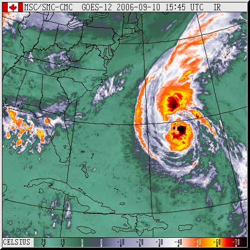
- Hurricane Florence seen on the GOES infra-red satellite image, Sunday morning
- As of today (Monday 11 Sept.), "Hurricane Florence is lashing Bermuda with winds just below hurricane force"
Link to Earth & Atmospheric Sciences home page.
Link to J.D. Wilson's home page.
Last Modified: 9 Dec., 2006